
The earth from the above
Space policy 2 February 2020In a time where fear and ignorance spread at fast speed, there is one thing that is even faster and straight at the same time, namely Earth Observation. Because what the satellite capture from the outer space is a scientific picture of the earth seen through the lenses of imaging devices.
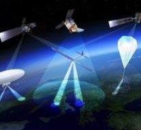
Earth observation (EO) is used to monitor the earth’s physical, chemical and biological systems, and assess its state and development both of natural and manmade environment. In remote sensing technologies, the device used to acquire data, is referred to as a “sensor”, usually many, that capture different sensitivities radiations. Sensors that use external energy sources to “observe” an object are referred to as passive sensors, versus the active sensor, which they have their own sources of radiation to “illuminate” objects so that the energy reflected and returned to the sensor may be measured.
Space-based technology, therefore, make use of these sensors to deliver set of repeat-cover dataset over a defined period of time, and combined with appropriate methods, they provide a unique way of gathering information on different aspects of the earth, including sea, oceans, land, icecaps, weather and atmosphere, as well as monitoring and preventing disasters.
Earth observation is very important because it can forecast weather, tracking biodiversity and wildlife trends, measuring land-use change (such as deforestation). Managing energy sources, freshwater supplies and agriculture; monitoring and responding to disasters, including fires, floods, earthquakes and tsunamis; predicting, adapting to and mitigating climate change. Finally, addressing emerging diseases and other health risks. Among many other interdisciplinary data EO can deliver, both of interest and importance for the current times we are leaving in, are the analysis of the “fingerprints” of the land, air or sea, that can enhance our understanding of the surrounding ecosystem and influence on human health. These data can also support disease preparedness and response actions for disease epidemic or humanitarian efforts. For example, EO satellites that use GPS in mobile phone technology – can locate precisely certain objects on Earth and, for example, outbreaks of a suspected source of contamination or the location of infected individuals.
At European level, Copernicus is the European system for monitoring the earth and is coordinated and managed by the European Commission. The basis for the institution of the European programme were laid in Baveno, Italy, in 1998. Since then, Copernicus has been the most successful Earth Observation programme in the world. There are seven satellites in orbit providing open data to hundreds of users. Until while ago, space data were only used by governments, scientists, and experts, and satellite imagery was not even stored, unless on magnetic tape. Only recently begun to be stored in cloud-based platforms, providing centralised access to Copernicus data and information, as well as to processing tools. These platforms are known as the DIAS, or Data and Information Access Services and are accessible to users.
References
https://www.who.int/bulletin/volumes/93/8/15-030815/en/
https://ec.europa.eu/growth/sectors/space/copernicus_en
https://ec.europa.eu/jrc/en/research-topic/earth-observation

